The Greenwich Park line or the South Eastern & Chatham Railway had a major impact on the buildings in West Greenwich, both during its construction through 1870-1880s and then again at the end of its relatively short life as new buildings appeared along its route. The line ran from 1888 to 1 January 1917 when it was closed on economic grounds. It did reopen for a short while but on 1 January 1926 the section of line from beyond Lewisham Road to Greenwich Park Station was finally abandoned. It took the opening of the DLR in 1999 to restore the direct rail link between Greenwich and Lewisham.
During the 2nd World War a bomb fell on part of the line (a section just north of Lindsell Street - see below). Post war the Greenwich Park terminus became a billiard club and by the 1960s the station had been filled in and used as a timber yard (see last shot below).
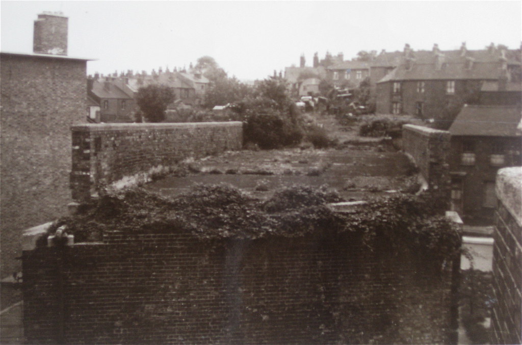
Today there is little evidence to show that a railway used to run through the heart of West Greenwich. Perhaps if you walk down Prior Street and look through the gates to the allotments, you could just about imagine a line coming across the allotment patch. If you were then to turn around by 180 degrees, you could just see it going through the patch of ground where Topham House now stands, to then dip under a tunnel at Blissett Street (see picture below). Perhaps not though. I wonder what happened to that tunnel? I also wonder if the residents of those nice Victorian Houses on Blissett street know they had (or still have) a whopping great tunnel under their front gardens!
Also have a look a the
Prior Street Allotment website - there are few pictures there too. A lot of the photos below come from the subbrit site - although most originate from the Greenwich Heritage Centre.
The first group of pictures below are maps of the area. This gives an idea of the route of the line and the impact on West Greenwich. The 1st map is from 1870 (pre line), the 2nd from 1894 and the 3rd from 1914. There's one other map I'd like to show here and that's the London County Council Greenwich Bomb map. This would then give a complete picture of how the route changed from 1870 through to post War. There's an awful lot that can be said about these maps. Not just about the impact of the Railway line but also on how West Greenwich has changed over the years. More on this in the
map pages.
One observation from the 1870 map is that those two mock Georgian style houses on Circus Street - well it looks like they replace two real Georgian ones there in 1870. Also the end of Prior Street was certainly bashed around a bit to accommodate the line - it lost a row of houses to the railway. It's pretty easy to see these and more changes looking at the maps. It does seem that the route was woven to minimise the impact on the buildings.
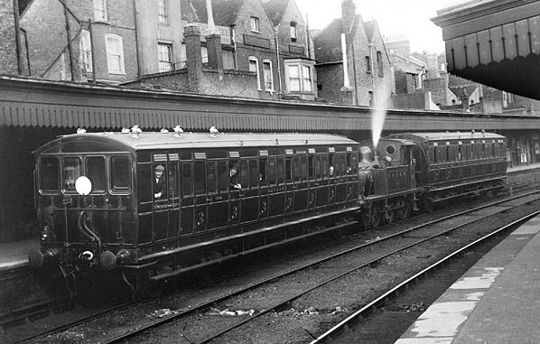
Blackheath Hill Station
The 1st picture below shows the Lewisham side of the Blackheath Hill station (where the Robinscroft Mews development is now). You can see the concourse on either side of the platforms. The 2nd picture is the Greenwich side. Both shots were taken circa 1920.

The 1st shot is the view you would have seen from BlackHeath Hill (looking southward). Taken in 1968. The 2nd shot was taken in 1980. The 3rd is from 1972. You can see the station but the line has been filled in. The 4th picture is from 1987 of the station being demolished.
This is the current day view
6 (c2006). You can see the Robinscroft Mews development in the top centre of the picture where the Blackheath Hill station once was. The building on the right of Robinscroft Mews below can just be seen in the 1968 shot above.
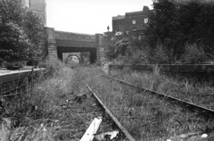
Between Blackheath Hill & Greenwich Park Stations
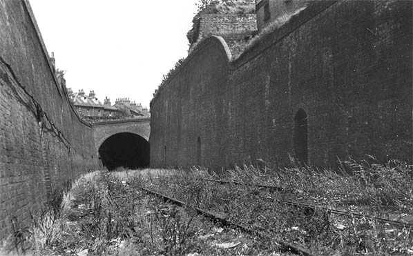
The 1st shot is looking at the entrance to the 150m of tunneling between Blackheath Hill and Greenwich Parkway. This must be the long tunnel that went under Blissett Street. I think this picture is looking northwards into the tunnel (i.e shot somewhere south of Blissett Street). The 2nd shot was found in a pile of other Greenwark Park line photos at the Greenwich Heritage Centre - it's the line going over Coldbath Street. See comments below for further details.
Greenwich Park Station
These next four pictures
3 are of the old Greenwich Parkway Station/track. Now the Ibis Hotel and car park. The first of the four shots must be looking away from the Parkway station building (i.e so Burney Street would be on left.). This is because the line veers off to the left. In the other three pictures the line veers to the right, so they must be shot looking towards the Parkway station building (you can just see it in the 2nd and 4th shot). The 3rd shot must therefore show the backs of the original buildings on Greenwich High Road (where the Cinema/ Cafe Rouge now stand). I think the three buildings in the top middle of the 3rd shot are a close up of the buildings half way up on left of the 2nd shot .
Back on the 1st shot, there are two lots of interesting buildings, the terrace on the left (which was the terrace in the middle of Burney Street - you can see it in the 1894 and 1914 map above. This is long gone presumed lost in the war) and that building in the middle of the shot in the far distance (which must have been one of the buildings on the north side of Royal Hill). If you click on the picture you can see a bigger version. It's the building with five windows on the 2nd or 3rd floor. Again you can see this row of houses on the maps above. This is where the care home (Serpia Court) now stands.
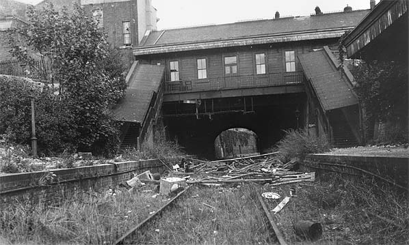
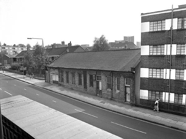
The left hand shot is the entrance to Greenwich Park Station on Stockwell Street. This was demolished in 1970. The right shot shows the old Greenwich Park Station building. (long thin building in the middle). The line has been filled in here and is being used as a timber yard. You can just make out the timber.
 Uploading ....